Features
Drilling
Noisy data?
Sometimes our data just doesn’t look the way the textbooks say it should
June 24, 2011 By Ken Hugo
Every driller has done a pump test and measured water levels to
determine well performance. Often, especially for long tests, pressure
transducers are used to collect the water level data. The water level is
easy to graph and the textbooks say the pump test data should look
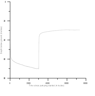
something like Figure A.
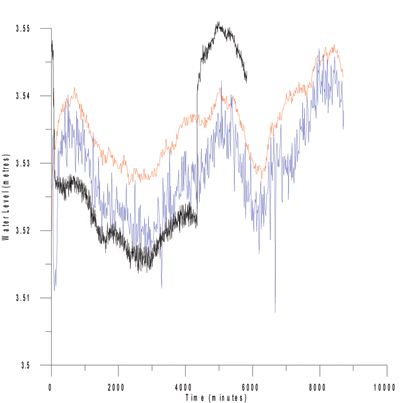
Every driller has done a pump test and measured water levels to determine well performance. Often, especially for long tests, pressure transducers are used to collect the water level data. The water level is easy to graph and the textbooks say the pump test data should look something like Figure A. But for some reason our water level data often looks like Figure B.
We understand that aquifers are not flat-lying beds that extend infinitely in all directions, and variations in aquifer properties will lead to deviations from a nice smooth curve, so perhaps that’s part of the problem. However, let’s consider other factors that are not related to the aquifer that may give us noise like this.

|
| Figure A
|
Firstly, we often get a lot of noise when we have little change in water levels during the test. The first graph shows a change in water levels during the test of about 40 metres, the second shows a change of about two centimetres. When one looks at the accuracy of a data logger, it’s quoted as a certain percentage of the data logger’s range. For instance, a data logger that can read a 100-metre range in water levels may have an accuracy of around five centimetres. An instrument with a five-centimetre accuracy may not be much good when we are looking for water changes of a few centimetres. Every reading can vary by five centimetres from the last reading and will still be displaying the same water level.
One solution is to use a data logger that has a smaller range. Of course, this is difficult because you may not know what the range in water levels will be before the test, or you may have no desire to acquire a collection of data loggers. Another solution may be to take readings at a less frequent time interval.
What else causes variations? Pumping from nearby wells that obtain water from the same aquifer may also interfere with the water levels in our well. Typically domestic wells will be pumped on an infrequent and short-term basis. The result may show up in your well as noise during the pump test – higher water level drops observed in your data when your neighbour’s well is pumped, lesser drops or even buildup when your neighbour stops pumping.
Sometimes there appears to be dropouts in the data – time when no readings are collected. This is often seen in the pumping well and is possibly due to electrical interference effects between the pump and the transducer.

|
| Figure B
|
Pressure transducers do not measure water level directly, but measure (obviously) pressure. The pressure of water is due to the height of the water above the transducer and the density of the water. We typically don’t worry too much about the density, because usually that does not change much. Water wells can produce gas and gas going into and out of solution can change the density by a fair amount. So if the well produces gas, the water level data may reflect this. A difference in levels may even be observed between levels collected from a pressure transducer and those collected using an electrical sounder.
Pump tests require constant pumping rates. Slight variations in pumping rates will cause quite significant changes in water levels, so regular checking of pump rates during a test is a good idea.
The above effects are man-made – real, but not related to any natural conditions. There are also some natural effects that can give us noise. Typically these items do not cause short-term noise that looks like the second graph shown above, but may account for long-term waves in the water level data. Some of these factors are as follows:
- Barometric: where confined aquifers are not directly exposed to the atmosphere, but the water in the well is. As a result, a change in atmospheric pressure can result in a few inches’ change in water levels. The amount of change is variable and depends on characteristics of the well and the aquifer (termed the barometric efficiency).
- Atmospheric: One can measure the air pressure during the test with a separate atmospheric (or barometric) transducer and compensate for changes in the well test software. If an atmospheric reading was not collected during the test, the Environment Canada website does report air pressure readings on an hourly basis for Calgary and Edmonton.
- Tidal: Galileo did not understand how tides worked. He thought it was related to the rotation of the earth. Not until Newton explained gravity could one understand that the gravitational pull of the moon can affect water levels in the ocean. This same attraction can affect water levels in wells. No tidal effects are found in shallow, unconfined aquifers in unconsolidated formations, but one to two centimetres of water level fluctuation on a six- to 12-hour cycle may be found in deeper aquifers. This fluctuation is not high enough to be observed during the pumping portion of the test, but may be seen in some tests if the data loggers are left in the well for a long buildup period and the water levels have achieved “static” conditions.
- Seismic: It’s been reported that changes in water levels may indicate earthquake activity (or may even predict earthquake activity). To see these effects one has to be close to the epicentre of the earthquake, which is not a common phenomenon. Earthquakes also generally last less than 30 seconds, so a data logger that reads at very short intervals (every 30 seconds or more often) would be required to observe this effect.
- Precipitation: In a shallow, unconfined aquifer with the water table close to the surface, a heavy rainstorm may raise the water levels during the test. Depending on the porosity and other factors of the aquifer, a good rain of a few inches in a day may raise the water level in the aquifer by several inches.
- Recharge / discharge: Water levels in aquifers may change slowly over time due to long-term climate trends. While we do not see these changes during a pump test, wells that measure water levels continuously over several years can show fluctuations related to yearly cycles (i.e., a rise in water levels during the spring or early summer, a decline throughout the rest of the year). Long-term drought conditions may also show up as continued drop in the water level in a well.
The textbook illustrations of pump tests show nice, smooth curves and assume homogenous aquifers with no boundaries and 100 per cent well efficiency with no well bore storage conditions issues. These ideal aquifer conditions are often not the case, and with the factors mentioned above it is not surprising to see variations in water levels, which, with enough knowledge and data, can be shown to be related to real physical causes.
Ken Hugo is a hydrogeologist and specializes in ground water assessments and ground water supply investigations. He works with property developers and municipalities on their ground water supply needs and can be contacted at khugo@levelton.com.
Print this page