Features
Mapping
Research
SkyTEM and XRI partner to provide water exploration system
April 24, 2014 By Ground Water Canada
 |
April 24, 2014, Ayr, Ont. – SkyTEM Surveys
and Exploration Resources International Geophysics are using
electromagnetic ground water mapping systems
to create 2-D and 3-D images.

|
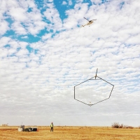
| SkyTEM system in flight, mapping ground water resources. |
 |
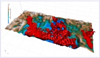
| 3-D model of quaternary aquifer. |
 |
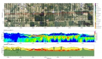
| Cross-section of quaternary aquifer. |
April 24, 2014, Ayr, Ont. – SkyTEM Surveys
and Exploration Resources International Geophysics are using electromagnetic ground water mapping systems and interpreting their data to create 2-D and 3-D images.
The collaboration is focusing on the
acquisition, modelling and characterization of ground water resources. The
partnership combines XRI’s geophysical and hydrogeological expertise and
SkyTEM’s state-of-the-art airborne aquifer mapping technology. This combination
of knowledge and tools for assessing fresh and saline water resources will help
communities, industries and resource sectors manage these limited and
vulnerable resources in a sustainable manner, said SkyTEM, of Ayr, Ont., in a news release.
SkyTEM’s airborne electromagnetic systems
are non-invasive and provide a quick, economical method for mapping ground water,
particularly for large areas or areas where land access is limited or
difficult. XRI, of Vicksburg, Miss., interprets the airborne data to deliver 2-D and 3-D images used
to build hydrogeological frameworks for ground water quality investigations,
ground water flow modelling and ground water management planning.
“SkyTEM was developed specifically to map
aquifers and this partnership allows us to deliver superior map products to our
clients while meeting their specific needs and schedules” said Bill Brown, regional
manager for SkyTEM Canada, in the release.
Print this page