Features
Sustainability
Water Issues
Updated atlas reveals top water-stressed areas
August 8, 2019 By Ground Water Canada
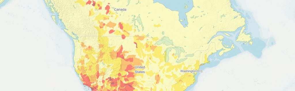 Map: World Resources Institute
Washington, DC – The World Resources Institute’s updated Aqueduct Water Risk Atlas finds that 17 countries, which are home to a quarter of the world’s population, face “extremely high” water stress.
The tool ranks water stress, drought risk, and riverine flood risk across 189 countries and their sub-national regions, like states and provinces.
The atlas uses a robust, peer reviewed methodology and the best-available information to create customizable global maps. Its updated hydrological model shows a more accurate, granular picture of water risk than ever before, the World Resources Institute said in a news release. The platform was used by more than 50,000 people in 2018.
In the 17 countries facing extremely high water stress, agriculture, industry and municipalities are drinking up 80 per cent of available surface and ground water in an average year. When demand rivals supply, even small dry shocks – which are set to increase due to climate change – can produce dire consequences, the WRI said.
According to the map, the areas most affected in Canada include areas around Medicine Hat, Swift Current and Saskatoon in Saskatchewan, and areas north of Calgary and south of Fort McMurray in Alberta.
Aqueduct sheds light on hot spots for water risk around the world. For example, in the Middle East and North Africa (MENA) region, home to 12 of the 17 countries facing “extremely high” stress, experts have pinpointed water scarcity as a force that can exacerbate conflict and migration. India, ranked #13 on Aqueduct’s list of “extremely highly” water stressed countries, has more than three times the population of the other 16 countries in this category combined. Northern India faces severe ground water depletion, visualized on Aqueduct’s maps and included in calculations of water stress for the first time.
“The recent water crisis in Chennai gained global attention, but various areas in India are experiencing chronic water stress as well,” said Shashi Shekhar, former secretary of India’s Ministry of Water Resources, and senior fellow for WRI India. “India can manage its water risk with the help of reliable and robust data pertaining to rainfall, surface, and groundwater to develop strategies that strengthen resilience. Aqueduct can help identify and prioritize water risks in India and around the world.”
Aqueduct’s tools map water risks such as floods, droughts and stress, using open-source, peer-reviewed data. Aqueduct now includes 13 indicators of water risk, including new additions such as ground water availability and water depletion, and monthly snapshots of water stress and variability.
Aqueduct is supported by the Aqueduct Alliance, a coalition of leading companies, governments and foundations working with WRI to improve sustainable water management. Its data were developed in collaboration with Delft University of Technology, Deltares, Utrecht University, Institute for Environmental Studies (IVM), PBL Netherlands Environmental Agency, and RepRisk.
To view the Aqueduct Water Risk Atlas, click here.
Print this page